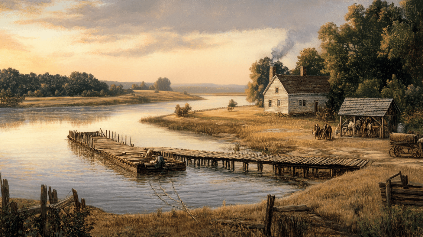
In the second decade of the 18th century, Robert Carter, whose beginnings trace back to New Poquoson Parish in York County, was living near the confluence of Beaverdam Creek and the James River in Henrico County on land he purchased from Tarlton Woodson. Around 1722, Robert identified a promising tract of land for a future homestead on the southern bank of the James River, approximately 16 miles upstream from his home and just a short distance downstream from the Buck Island plantation at Byrd Creek. This land, positioned between the mouths of Muddy Creek and Willis Creek, offered fertile soil and direct access to the James River—ideal for both farming and trade.
Having scouted this piece of land, Robert embarked on the process of acquiring it through Treasury Rights, one of the avenues settlers could use to secure a patent. Unlike the headright system, which granted land for transporting individuals to the colony, Treasury Rights required the payment of a fee to the colonial government. This process began with a visit to the county courthouse in Henrico, located in the small settlement of Varina. There, Robert filed his claim, paid the necessary fees, and began the legal proceedings to secure his ownership.
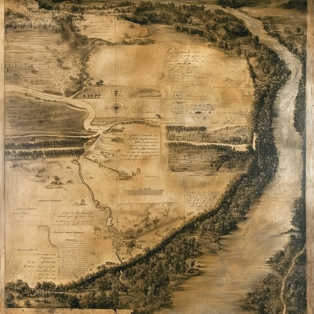
With his claim officially on record, Robert returned to the land to fulfill another critical step in the process: the survey. Colonial laws required that a qualified surveyor measure and map the land, establishing its precise boundaries. This survey ensured that there were no disputes over the tract and that the exact location and size were documented for future reference.
Understanding the complexities of colonial bureaucracy, Robert likely entrusted a local agent to handle the submission of his completed documents to the Governor’s Council in Williamsburg. This step was vital, as Williamsburg was the seat of Virginia’s colonial government, where land patents were reviewed and approved. By relying on an agent, Robert ensured that his application moved through the proper channels efficiently, sparing him the long and arduous journey to Williamsburg.
Finally, on August 17, 1725, Lieutenant Governor Hugh Drysdale signed the official land patent, granting Robert Carter ownership of the 327 acres he had worked so diligently to acquire. This document, sealed with the authority of the colonial government, marked the culmination of years of effort. For Robert, it wasn’t just a piece of paper; it was a testament to his vision and perseverance, a new beginning for his family’s endeavors in Henrico County, where the land would play a central role in shaping their future.
Virginia Patent Book 12, pg. 301

George and To all and Know Ye, That for divers good causes and consideration but more especially for and in consideration of the sum of thirty five shillings of good lawful money for our use paid to our Receiver General of our Revenue in this our Colony & Dominion of Virgina. We have given granted and confirmed and by these presents for us our heirs and successors do give grant and confirm unto Robert Carter of Henrico County one certain tract or parcell of land containing three hundred and twenty seven acres lying and being on the south side James River between Muddy and Willises Creeks in the County of Henrico aforesaid and bounded as followeth, to wit; Begining at a corner Robert Hughes corner ash being the upper corner on the River of the Muddy Creek survey thence up the River according to its meanders one mile to a corner black oak on the River bank thence into the woods west twenty eight degrees south one hundred chains to a corner white oak thence east sixty chains to a corner white oak thence east thirty degrees south forty three chains to a corner white oak thence east forty degrees south eighty chains to a corner white oak thence east twenty eight degrees north thirty chains to several poplars on the line of Robert Hughes, thence on the line to the beginning, the differance being one hundred chains.
With all and To have hold and to be held and yielding and paying and provided and In witness and witness our Trusty and well beloved Hugh Drysdale Esq our Lieutenant Governor at Williamsburg under the seal of our said Colony the seventeenth day of August one thousand seven hundred and twenty five in the Twelfth year of our reign. Signed Hugh Drysdale
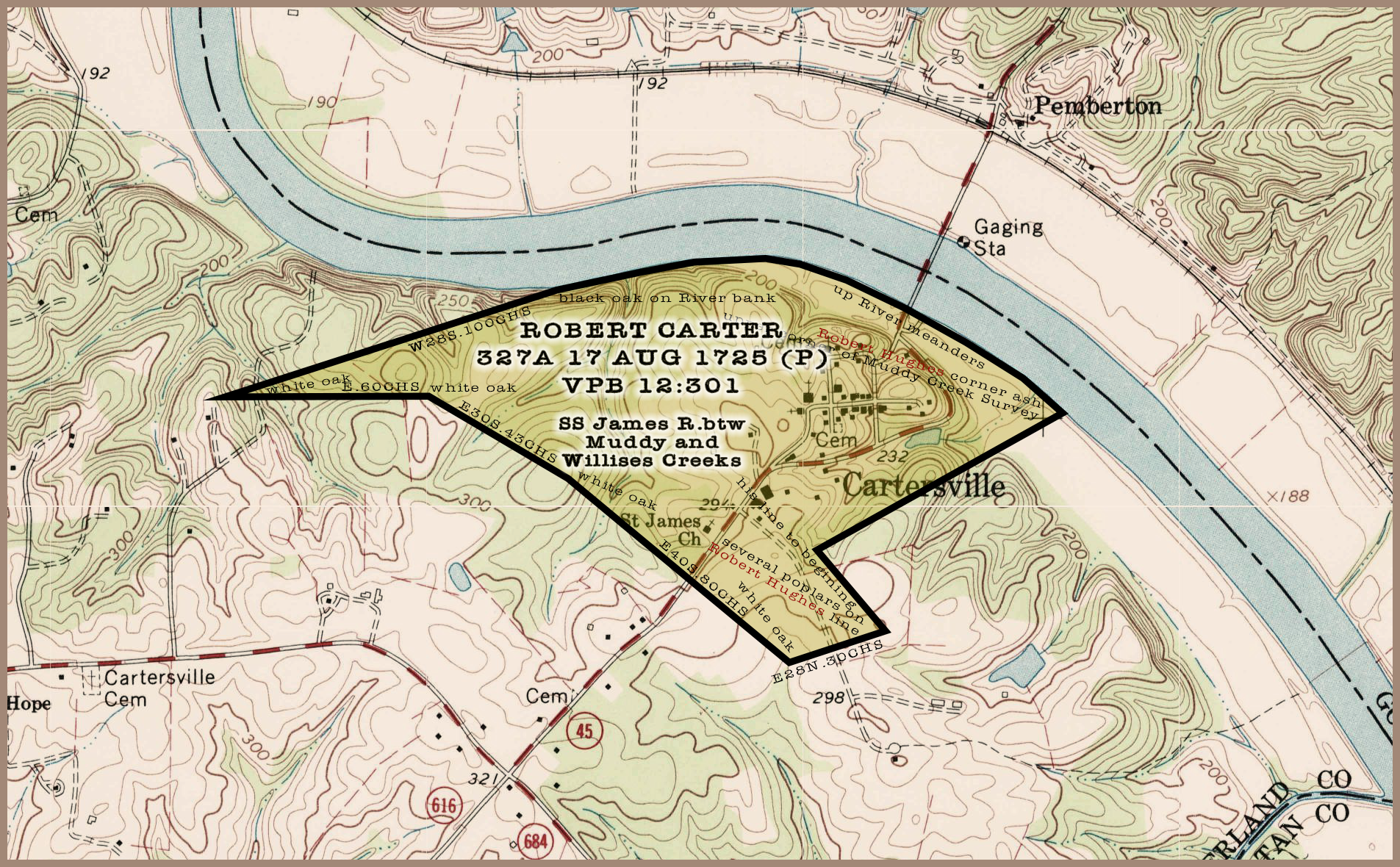
The detailed description in the patent outlines the property’s boundaries, starting at Robert Hughes’s corner ash near Muddy Creek and following the meandering James River for a mile. The land extended deep into the woods, marked by a series of corner oaks and poplars, and was meticulously surveyed to cover 327 acres. The diverse topography, from riverbanks to wooded areas, would have provided Robert with ample resources for farming, livestock, and timber.
Goochland County
On May 1, 1728, the General Assembly of Virginia enacted a law to divide Henrico County into two separate counties. The act stated:
“…County of Henrico be divided into two distinct Counties, And that the Division be made by a Line on the North side James River beginning at the mouth o Tuckahoe Creek, thence up the said Creek to Chumley’s Branch, thence along a line of marked Trees North, Twenty degrees, East to Hanover County, And on the South side James River beginning at the Lower Manachin Creek, from thence along a line of marked Trees in a direct course to the mouth of Skinquarter Creek on Appomatox River, And that that part of the County lying below the said line shall forever hereafter be called and known by the name Henrico County And that that part of the County lying above the said line shall be called and known by the name of Goochland County …”
(Waverly K. Winfree, The Laws of Virginia, Being a Supplement to Hening’s The Statutes at Large, 1700-1750, pg. 321)
This division placed Robert Carter’s property within the newly established Goochland County.
In 1742, Robert Carter likely made a pivotal decision that would shape both his legacy and the landscape of Goochland County. Recognizing the strategic location of his property along the James River, Robert may have spearheaded a petition to the colonial government to establish a ferry crossing at his land. The ferry would not only serve his own interests by increasing access to his property and fostering trade but also benefit the growing community by providing a much-needed transportation link across the river. Such a petition would have been a carefully considered initiative, likely supported by local merchants, travelers, and residents who saw the value in improving connectivity in the region.
The petition process itself would have taken time. After submitting the formal request to the government, detailing the proposed ferry’s location and its importance to the surrounding area, the idea would have gone through colonial channels for approval. This included reviews by the Governor’s Council and discussions among lawmakers, who would evaluate the ferry’s economic and logistical benefits.
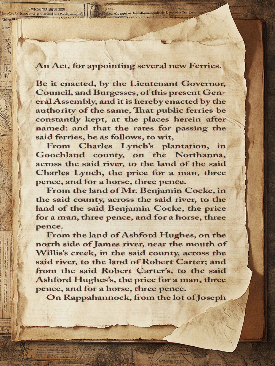
In September of 1744, an important piece of legislation was passed that directly impacted Robert Carter’s family and their property. The Virginia General Assembly enacted a law establishing new public ferries, including one crossing the James River from Ashford Hughes’s land to Robert Carter’s property near the mouth of Willis’s Creek. This ferry officially recognized and regulated a crossing point on the Carter family’s land, which likely played a significant role in the local economy and connectivity of the region.
This act represents a key moment in the Carter family’s history, showcasing their integration into the economic and social fabric of Goochland County during the mid-18th century.
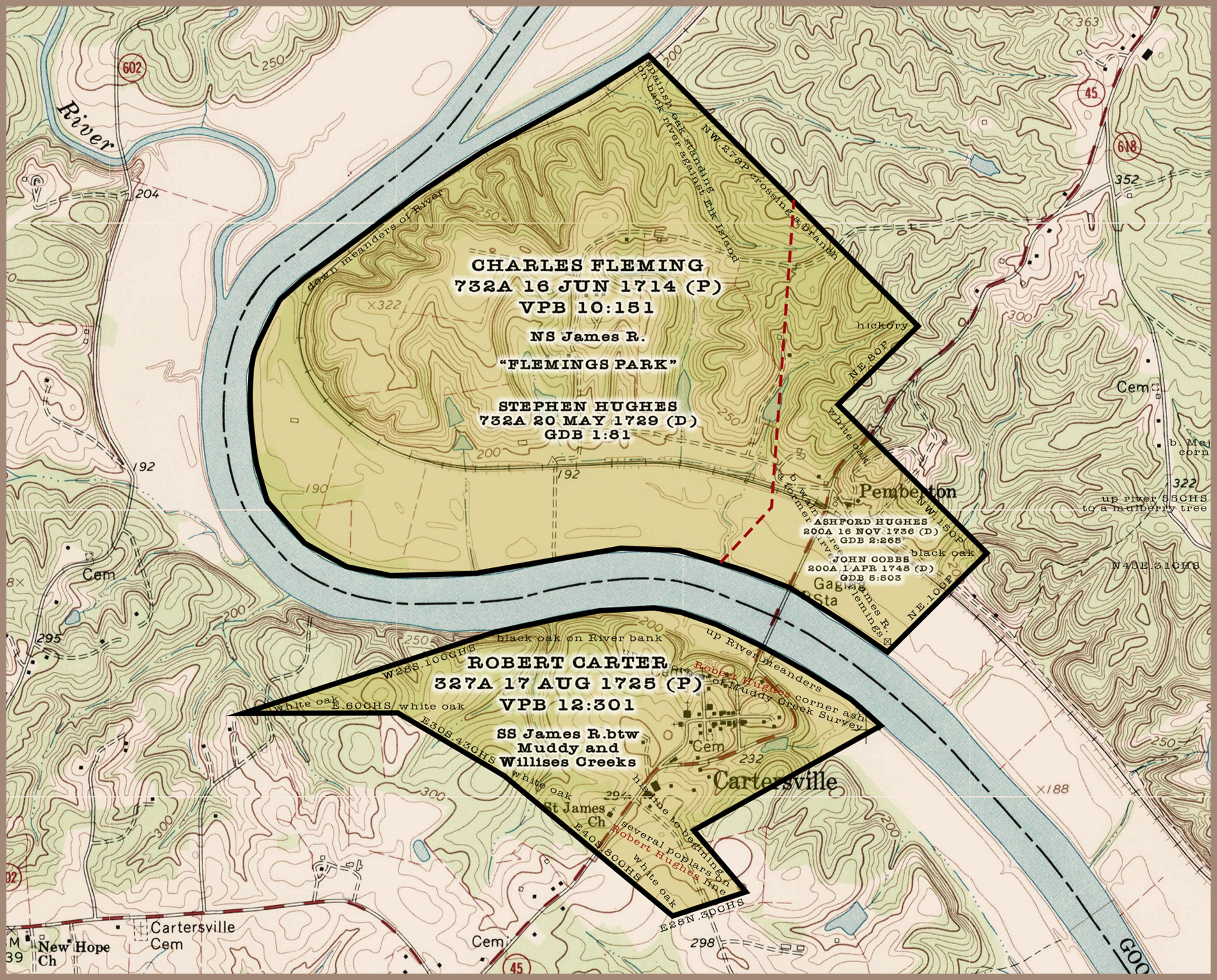
The land on the north side of James River where the other ferry point was located was on the land owned by Ashford Hughes. The original patent for this land of 732 acres was granted to Charles Fleming in 1714 and after his death, his son sold it to Stephen Hughes. Stephen then sold 200 acre out of the tract known as “Flemings Park” to his brother Ashford Hughes in 1738.
Court Mentions of Carter’s Ferry
Carter’s Ferry road to be viewed – On the motion of Robert Carter ferry keeper, Arthur Hopkins, John Smith and Peter Jefferson are appointed to vew the ground for a road from his ferry on the north side of James River into the main road and make report thereof to the court. July Court 1745 (GOB 6:90)
Surveyor of road – John Lee is appointed Surveyor of the road from Robert Carters Ferry into the old Bird Road and the tiths belonging to Bowler Corke, James Shaelton, Allen Howard, John Lee and John Massie are ordered to clear the same and it is also ordered that the said John Lee and the tithables before mentioned do clear the road from the old Byrd ford down to Mr. John Smiths. January Court 1745 (GOB 6:141)
Carter’s Ferry Road – Ordered that Robert Carters Ferry Road be continued across the main road to Mims’s Bridge and from thence to the church and that John Bollings Tithables at his Island Plantation do work on the said road under John Lee, Surveyor. November Court 1747 (GOB 6:393)
Road to be opened – Ordered that the gangs belonging to Mesby’s Ferry Road and Carters Ferry Road do assist Thomas Carter in opening a road from the River Road near John Smith Gentleman, into the Church Road at Mims’s Bridge. June Court 1753 (GOB 7:223)
Surveyor of a Road appointed – Ordered that day born Rice, open a road from John Woodson’s near Carter’s Ferry into the church road at William Swift’s Plantation, and that the hands of Samuel Gist, Reuben Shelton & Archibald Jarrett, do work on the said road. May Court 1754 (GOB 7:334)
Cumberland County
On May 20, 1749, the General Assembly of Virginia enacted a law to divide Goochland County into two separate counties. The act stated:
“…County of Goochland be divided into two Counties, that is to say, all that part of the said County of Goochland, lying on the south side of James River, shall be one distinct County and called by the Name of Cumberland County, and all that other part of the said County of Goochland, on the north side of James River aforesaid, shall be one other distinct County and retain the Name of Goochland County…”
(Waverly K. Winfree, The Laws of Virginia, Being a Supplement to Hening’s The Statutes at Large, 1700-1750, pg. 426)
This division placed Robert Carter’s property within the newly established Cumberland County, while the ferry point on the north bank of the James River remained in Goochland County. This change would have influenced administrative matters for Carter’s Ferry, as it now operated across two separate jurisdictions.
Robert Carter devoted much of his remaining time to operating Carter’s Ferry and managing the surrounding land along the James River. For more than 14 years, Robert worked to ensure the ferry provided a vital connection across the river, serving travelers and commerce alike. His property, a 327-acre tract on the southern bank of the James River between Muddy Creek and Willis Creek, became synonymous with his family name and the bustling activity the ferry brought to the area.
As he neared the end of his life, Robert Carter formalized his plans for the property. On September 15, 1753, he created his Last Will and Testament, bequeathing the 327-acre tract to his son Charles Carter. This decision not only passed on the family’s land but also symbolized a legacy of hard work and enterprise. Six years later, on May 28, 1759, Robert’s will was presented and recorded in open court, marking the close of his chapter and the beginning of a new one for his family.
On June 21, 1760, Charles Carter, along with his brother Robert Carter Jr and mother Mary Carter, sold the 327-acre property to John Woodson. While the deed did not explicitly mention the ferry, Woodson also took over ownership and operation of Carter’s Ferry. For many years following this transaction, John Woodson managed the ferry, continuing its critical role in connecting the communities on either side of the James River.
Cartersville
Carter’s Ferry, a significant crossing point on the James River, earned a place in history as one of nine posts utilized during the American Revolution for the distribution of army quartermaster stores and ammunition under the supervision of Major Claiborne. Its role during this pivotal time highlights its importance to both local and national efforts.
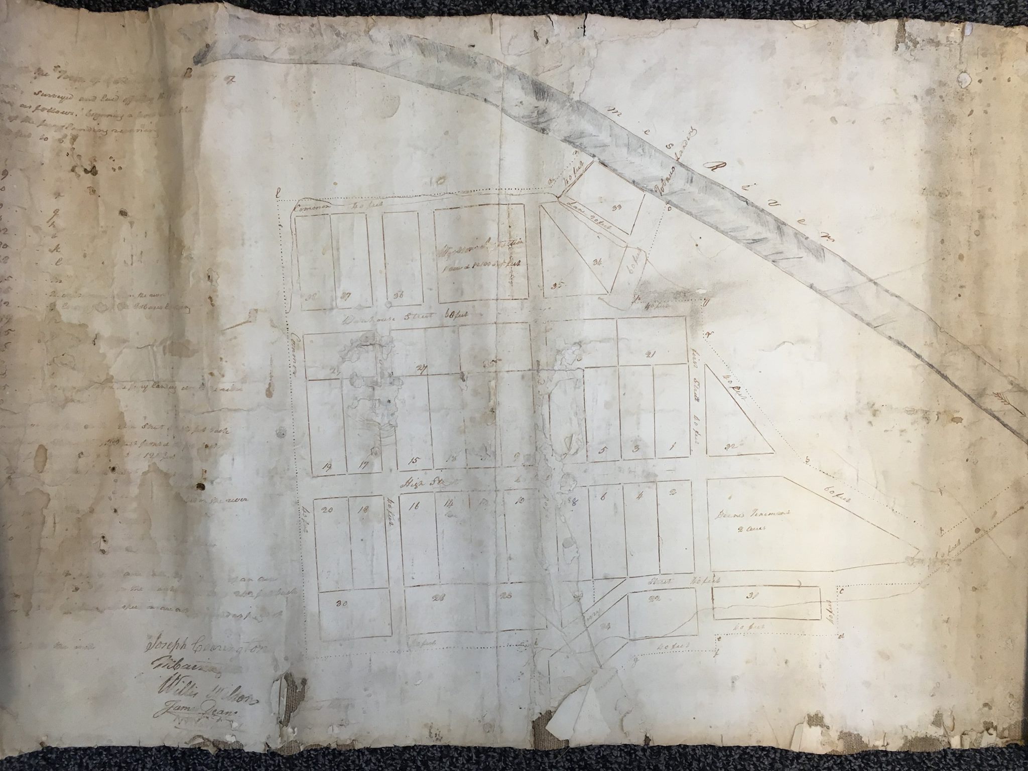
On December 16, 1790, the Virginia General Assembly established ‘Cartersville’ on 27 acres of land owned by John Woodson, encompassing his ferry and tavern. Local citizens from Cumberland, Buckingham, and Powhatan counties petitioned for the town, which was laid out in half-acre lots by Joseph Carrington, Mayo Carrington, Willis Wilson, James Deane, Walter Warfield, and William Ronald.
The name “Cartersville” was a direct nod to Carter’s Ferry, itself named for Robert Carter, whose name became part of the enduring legacy of this historic crossing.

Leave a comment