
I’ve decided to jump over to Cumberland County, North Carolina to start plotting some land grants and deeds. I was interested in locating the land that Hardy Smith bought from Richard Smith in 1783.
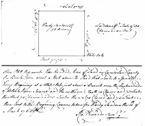
Hardy Sanders was issued a land grant on 22 May 1772 for 500 acres in Cumberland County, North Carolina on the Black River a mile above the road that leads to Sprowels Ferry. The tract begins at a white oak just above a Branch near the Eastern Side of Black River.
The next task was to determine where Sprowels Ferry was located and try to find a road that originated in the vicinity of the ferry and then crossed the Black River. I ran across these two maps:
Sketch of Cumberland County, North Carolina

What I see on this sketch is Smith Ferry marked opposite the mouth of Lower Little River. This ferry was owned and operated by Alexander Smith who was the son of John Smith Sr of Johnston’s County, North Carolina. Running north from Smith’s Ferry is a road that terminates at Sprowels Ferry. Then there is a road that runs north east (actually north based on today’s maps) across the Black River, which is the first river the road crosses.
A bonus for me, depicted on the south west corner of the full sketch is Cole’s Bridge on Drowning Creek. When my Cole ancestors (William Cole b. 1738, d. 12 August 1809) migrated to North Carolina from Chester Pennsylvania, stopping in several counties in Virginia along the Great Wagon Road, they established themselves on Drowning Creek and Salisbury to the north.
The second map, First Actual Survey of the state of North Carolina :
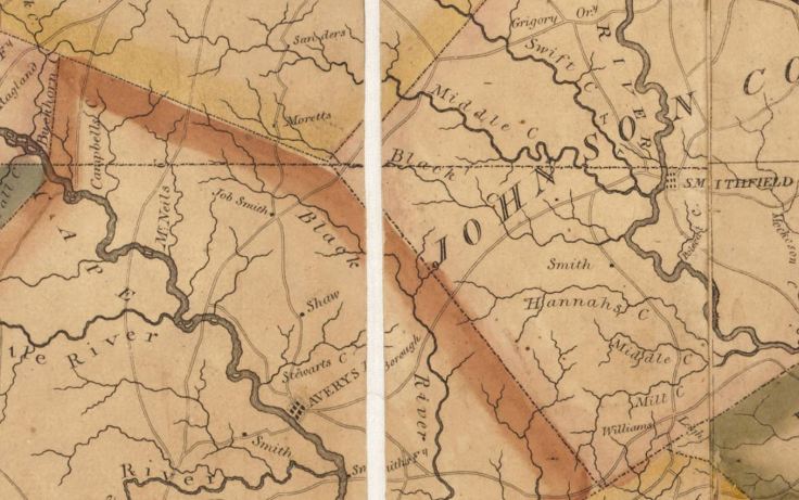
What I see on this map is Smith Ferry marked opposite the mouth of Lower Little River. A road running north in the vicinity of Smith’s Ferry, intersecting Averasboro and then terminating near Sprowels Ferry. Then a road running north, passing Job Smith’s property before crossing the Black River. Based on my research this is likely the ‘road that leads to Sprowels Ferry’. This road also follows the general track of what is today the ‘Old Stage Road’.
Also of note, is at the top of the above snippet it shows the land owner Sanders. This is likely Hardy Sanders (b. 1747), known as a resident of Wake County and held property in Wake on Middle Creek. Also either his father James or brother James was granted 260 acres of land on Middle Creek & Cow Branch in 1757. This made the Sanders family adjacent land owners to Samuel Smith Sr. Hardy’s son Hardy married Edith Turner, a grand daughter of Samuel Smith Sr, and Hardy’s son Reuben married Keran Ann Smith, a daughter of Samuel Smith Sr.
On 17 May 1774, Hardy Sanders, of Wake County, sold this 500 acre tract for 100 pounds (equivalent to $15,425 in today’s money) to Richard Smith of Cumberland County.
This deed shows the beginning of this tract starts at a white oak just above a branch near the eastern side of Black River near the road that leads to Sprowl’s Ferry. The deed was written in the presence and proved in the Oct Term 1774 by John Smith (this John Smith is believed not to be the John Smith Sr or John Smith Jr of Johnston County but the John Smith who was a land owner a couple of miles down the Black River). William Ward is the other witness to this deed. William Ward was an adjacent land owner to John Smith (presumed to be John Smith Sr of Johnston County) on the north side of Neuse River on Buffalo Swamp and on the south side of Neuse River on Poplar Swamp. He was also an adjacent land owner to Samuel Smith Sr on the north side of Neuse River.

On 6 October 1783, Richard Smith sold this 500 acre tract for 100 pounds to Hardy Smith. This deed was witnessed by Ebenezer Folsom, Hugh Ochiltree, and Nathaniel Folsom. Nathaniel proved this deed in the January 1785 term. Ebenezer and Nathaniel are sons of Ebenezer Folsom Sr and Edith Smith (a daughter of Samuel Smith Sr).
On 7 October 1787, Hardy Smith sold this 500 acre tract for 80 pounds ($12,340 in today’s money) to John Wilder. This deed was witnessed by John Green and Jacob Smith. John Green proved this deed in the January 1790 term. Both John and Jacob are nearby (Black River) land owners. John Wilder’s brothers Samuel and William were land owner in Johnston County (Little River & Buffalo Swamp). Also, John Wilder’s daughter Lucretia Wilder married Job(e) Smith, kin to Hardy Smith (kinship presumed based upon DNA evidence/research).
John Wilder died in 1800 and he willed his daughter 461 1/2 acres and his son William Mann Wilder 170 acres. The remainder of the land, approximately 30A was to be set aside for a grave yard. John’s LWT was signed by John Wilder, Jobe Smith, Mary Wilder and William Mann Wilder.

On 12 May 1801, Job Smith (Lucretia’s husband) sold 300A, the western portion of the 500A to Creed Collins (shaded and shown on the map below). Job also sold the remaining portion (161 1/2 acres) of the 461 1/2 acres that was willed to his wife, to Creed Collins. This was a tract of land patented to Matthew Myat in 1790 and sold to John Wilder on 4 Oct 1792. Creed Collins would sell both tracts totaling 461A to Francis & Samuel Young. Samuel Young, in his 1810 will, wished to sell his portion to James Renfro or whomever by the executors. (The Renfro’s are a kindred family to the Cole’s. Research is needed to determine James Renfro’s exact connection to the Renfro’s and Cole’s of Pennsylvania).
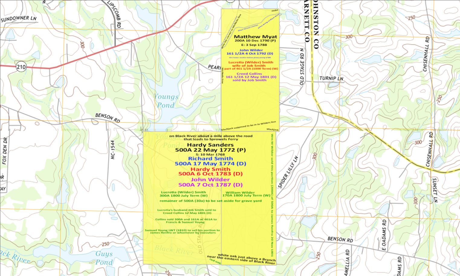
This map shows where the Hardy Sanders and Matthew Myatt properties were located in what is today Harnett County in the eastern boundaries of Angier.

Leave a comment